


Erdre rive droite

Vinceneux
User

Length
6.8 km

Max alt
31 m

Uphill gradient
82 m
Km-Effort
7.9 km

Min alt
3 m

Downhill gradient
90 m
Boucle
No
Creation date :
2020-11-22 14:50:31.417
Updated on :
2020-11-22 16:26:00.611
1h33
Difficulty : Very easy

FREE GPS app for hiking
 SityTrail
IGN / Geographical institutes
SityTrail Plus
The world is yours!
About
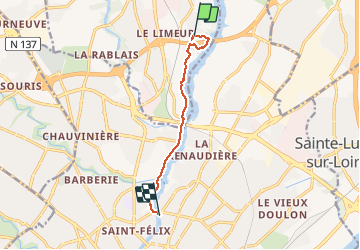
Trail Walking of 6.8 km to be discovered at Pays de la Loire, Loire-Atlantique, La Chapelle-sur-Erdre. This trail is proposed by Vinceneux.
Positioning
Country:
France
Region :
Pays de la Loire
Department/Province :
Loire-Atlantique
Municipality :
La Chapelle-sur-Erdre
Location:
Unknown
Start:(Dec)
Start:(UTM)
610753 ; 5236970 (30T) N.
Comments